CONVENTIONAL & AERIAL
SURVEYS
Our Professional Surveying Services
-
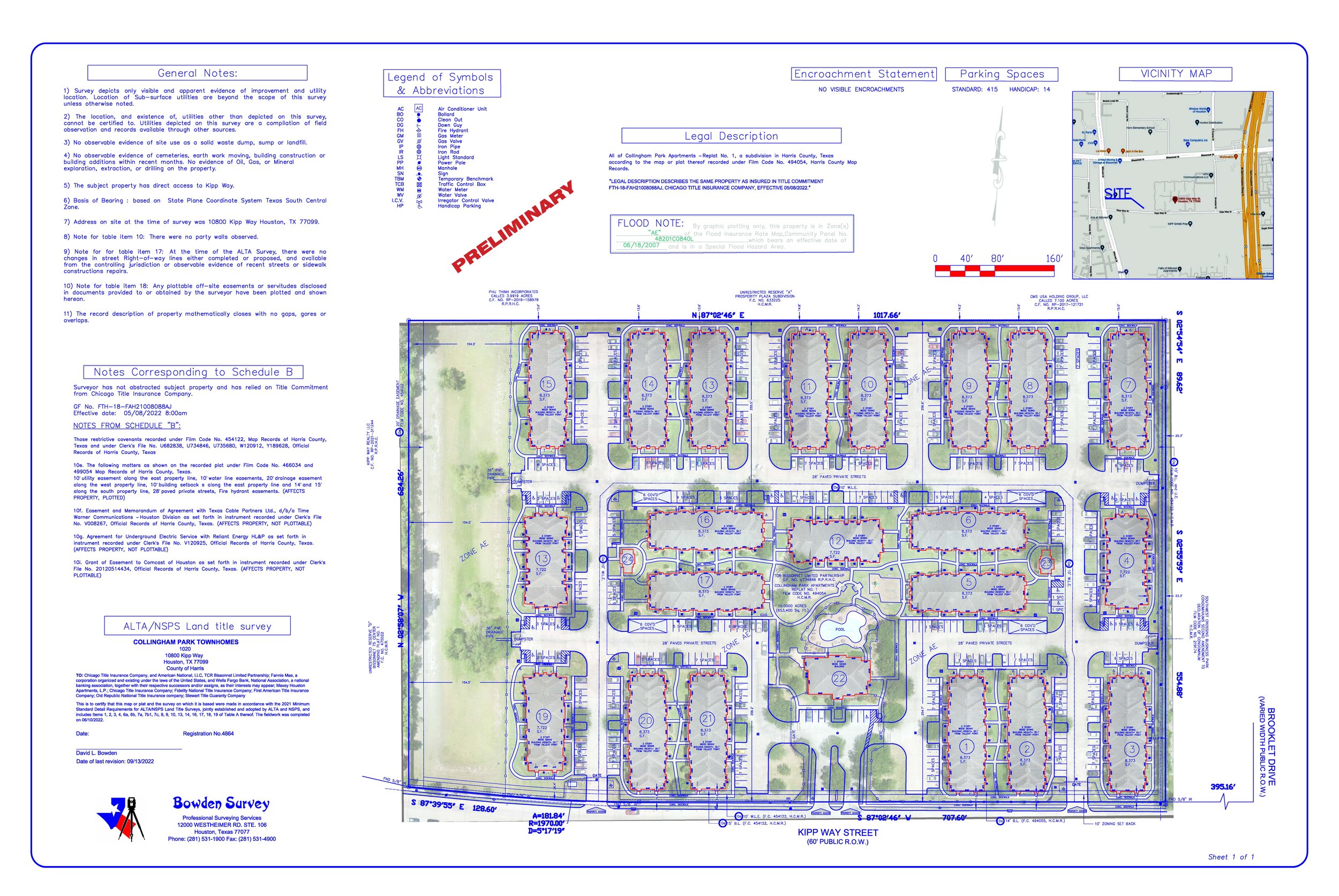
We provide ALTA/NSPS Land Title Surveys that meet national standards for commercial real estate transactions. These surveys identify property boundaries, easements, rights-of-way, improvements, and encroachments to support title insurance, lending, and due diligence requirements.
-
A Boundary Survey identifies the exact legal limits of a property by locating and marking corners, lines, and recorded deed information. This service is essential for anyone purchasing land, building new structures, resolving disputes with neighbors, or verifying acreage. Boundary Surveys protect clients from encroachments, legal conflicts, and costly construction mistakes by ensuring everyone understands precisely where a property begins and ends.
-
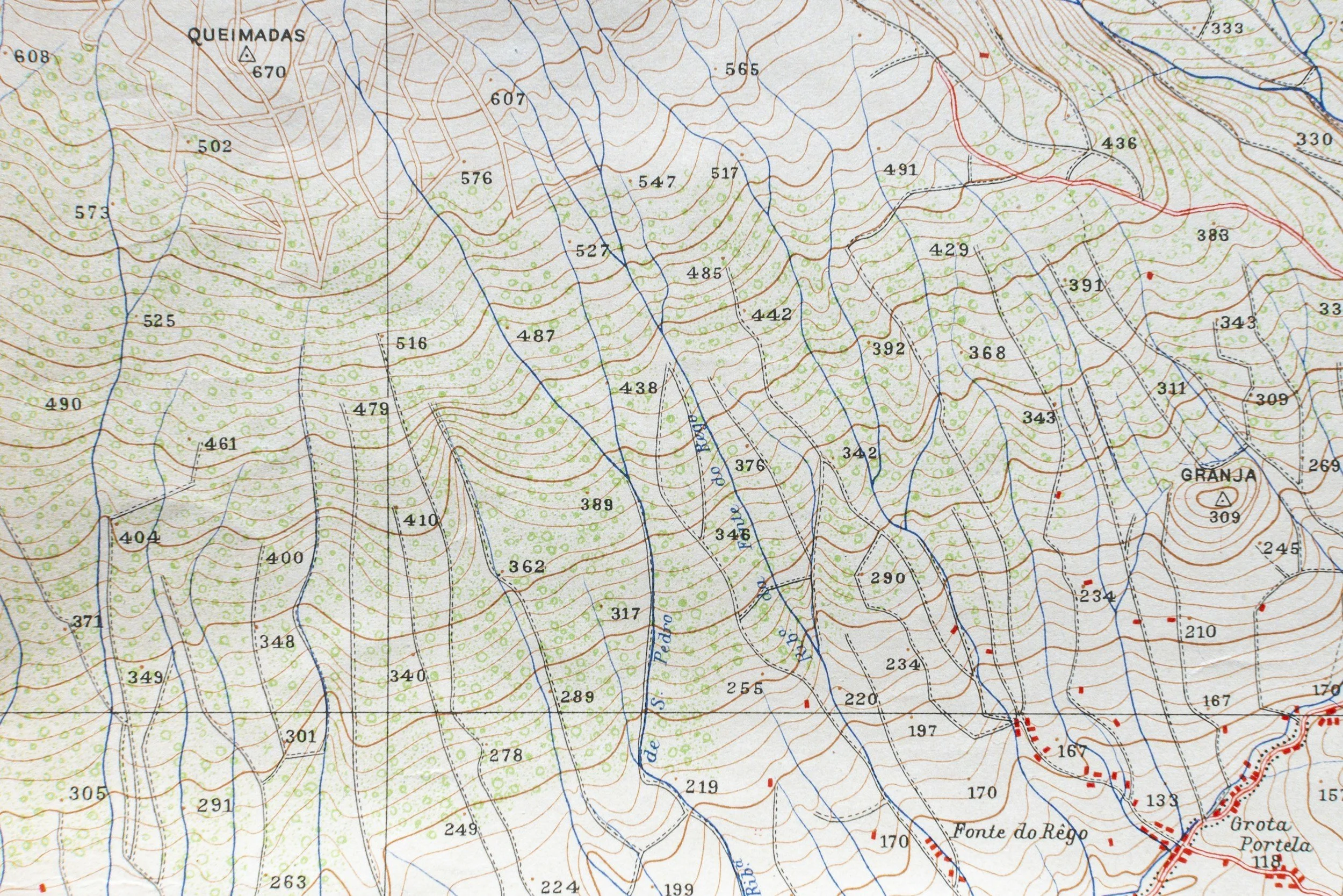
A Topographic Survey maps the natural and built features of a property, including elevations, contours, trees, buildings, drainage paths, and utilities. Engineers and architects rely on this data to design site plans, determine grading, manage stormwater, and understand how the land will interact with new construction. Clients need topographic surveys to ensure designs are accurate, compliant, and meet to the actual conditions of the property.
-
Platting and subdivision services involve dividing land into legally recognized lots, preparing plats for city or county approval, and documenting easements, rights-of-way, and property boundaries. This is a critical step for developers, investors, and landowners looking to sell parcels, create residential communities, or formalize property divisions. Clients need this service to ensure their development complies with local regulations, avoids legal issues, and moves smoothly through the municipal approval process.
-
Construction Staking translates engineering and architectural plans into physical markers placed directly on the ground, showing crews exactly where to build. This includes marking building corners, utilities, roads, and elevation points. Clients need construction staking to keep projects on track, accurate, and compliant with design specifications. Precise staking reduces rework, prevents costly alignment errors, and ensures structures are built exactly where they are intended.
-
Large-scale commercial and engineering projects depend on high-precision surveying to guide design, permitting, site preparation, and ongoing construction activities. This includes detailed mapping, layout of utilities and structures, and verification surveys to ensure compliance with plans. Clients need this service to keep complex projects safe, efficient, and accurate, minimizing risk and ensuring that every phase of construction is aligned with professional engineering standards.
-
Custom Mapping provides tailored mapping solutions that present specific site data such as easements, flood zones, utility networks, improvements, or high-resolution aerial imagery. These maps are engineered to support design decisions, permitting, planning, and project presentations. Clients need custom mapping when standard surveys don’t offer the level of detail or visualization required for their unique project goals, stakeholder communication, or regulatory needs.
Bowden Survey provides accurate, reliable land surveying solutions for residential, commercial, and large-scale development projects. Our services are designed to support builders, engineers, developers, and property owners with the precise data they need to plan, design, and build with confidence.
Previous Work Examples